TT Talk - an active Atlantic hurricane season forecast

Risks to the global supply chain from climate change are inevitably operation dependent and geographically dynamic. In recent years, operations have been impacted by wind microbursts and heavy rainfall, through to droughts and wildfires, all seemingly occurring with increasing frequency, in unexpected locations and with increased ferocity.
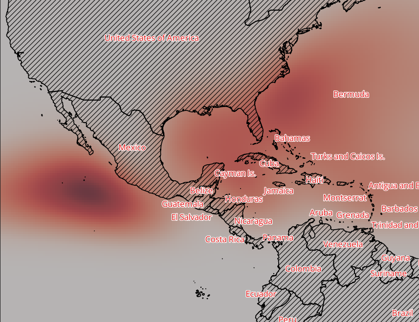
Historically the annual Atlantic hurricane season, driven by the sea temperature of the Atlantic Ocean, has been more predictable, typically running from 1 June through to 30 November each year and affecting the area shown below in fig 01. The most prominent impact is where hurricane category storms make landfall, with the Caribbean, East Coast US and the Mexican Gulf historically being most exposed geographically.
Defining storms
The National Oceanic and Atmosphere Administration (NOAA) provide a helpful definition of the various storm types experienced.
Tropical cyclones (a rotating low-pressure weather system) with maximum sustained surface winds of less than 39 miles per hour (mph) are called ‘tropical depressions’. Those with maximum sustained winds of 39 mph or higher are called ‘tropical storms’. When a storm's maximum sustained winds reach 74 mph, the storm becomes a ‘hurricane’.
The Saffir-Simpson Hurricane Wind Scale is a 1 to 5 rating, or category, based on a hurricane's maximum sustained winds. The higher the category, the greater the hurricane's potential for property damage.
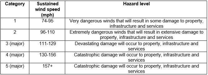
The higher the category, the greater the hurricane's potential for property damage
Risk exposure
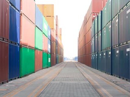
In terms of exposure, ports and terminal operations located in coastal zones are at greatest risk of damage to property, handling equipment and cargo transiting. However, the disruption caused by a hurricane making landfall can be significant for all supply chain actors, including those located well inland, not least the welfare of personnel and the availability of roads and infrastructure to continue cargo operations both during a hurricane and in the – potentially extended – aftermath.
Common risks include:
- Severe flooding from prolonged heavy rainfall
- Dangerous storm surges
- High winds and micro bursts
Dynamic risk
Those operating within historically active locations will be well aware of the risks and the importance of adequate preparation. As the dynamic of climate change risk changes however, hurricanes could make landfall in less predictable locations. This drives the great importance that the industry is prepared and operations sufficiently resilient to overcome the presented challenges.
TT has provided related risk management guidance over a number of years through this newsletter, risk assessment site visits and many industry presentations. The Club’s Windstorm II guidance handbook also provides a comprehensive storm preparedness checklist and an in depth consideration of the risks, together with risk mitigation strategies.
As the dynamic of climate change risk changes however, hurricanes could make landfall in less predictable locations
2024 forecast
The National Tropical Weather Conference Colorado State University (CSU) hurricane researchers predicted an extremely active Atlantic hurricane season in their initial 2024 forecast. The team cited record warm tropical and eastern subtropical Atlantic sea surface temperatures as a primary factor for their predictions for the 2024 season. Recognising that a hurricane’s fuel source is warm ocean water, the current recorded conditions give rise to the conditions that drive the formation of hurricane strength storms.
Consequently, the CSU team predict 23 named storms during the 2024 Atlantic hurricane season, forecasting that eleven of those will develop into hurricane strength storms and five to reach major hurricane strength (categories 3, 4 & 5), significantly above the average season between 1991-2020.
Risk mitigation
The onset of the tropical storm season is a timely reminder to review, test and update their hurricane safety procedures to ensure all staff are familiar with the protocol. This applies to all coastal and inland facilities, particularly those located along the Atlantic seaboard, the Caribbean and the Gulf of Mexico.
As a part of a crisis management plan, there is great importance in ensuring that personnel are aware of specific roles and responsibilities, including communication and escalation procedures.
While the path and extent of extreme storms are typically predicted several days in advance, giving operators valuable time to take action to prevent the worst damage, experience supports the need for constant vigilance concerning general operational standards. This would include ensuring that cranes are pinned and tied down when not in use and operators are instructed on actions to take where unexpected gusts of wind are experienced.
The Windstorm II handbook provides extensive guidance. However, below is a non-exhaustive list of actions below that could be considered in advance of a forecast storm to protect personnel, assets and liabilities.
- Take empty container stacks down to two high, laden containers to three high. Form stacks in a pyramid format where possible
- Do not stack containers in low lying areas for fear of flooding; storm surge is common
- Store small and loose equipment indoors
- Housekeeping - remove all debris that could potentially cause damage if swept up in either storm surge or high winds
- Where possible minimise the volume of cargo on site – consider stopping acceptance of export containers in the days prior to the forecast storm
- Clear debris from storm pin points and drainage systems. Ensure that pumps are fully operational where used to avoid floods
Summary
The time to consider exposure to such risks is always in advance; preparation is key to ensuring that personnel and property are protected and to maximise operational resilience.
While this article focuses on the North American and Caribbean risks, recognise that other parts of the world are exposed, whether within the tropics or not. Winds gusting up to hurricane strength (Beaufort force 12 or 32.7 m/s) are not restricted to latitude, proximity to the coast or the season.
*The CSU team will issue additional forecast updates on 11 June, 9 July and 6 August.
-
If you would like further information, or have any comments, please email us, or take this opportunity to forward to any others who you may feel would be interested.
Documents
TT Talk Edition 310 (Chinese) (1.05 MB) 28/05/2024
- Author
- Neil Dalus
- Date
- 07/05/2024